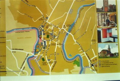
112 (2) The map of Pont-sur-Sambre (on the sign-board).

This is a detail of a sign-board of the last post. You can see here how the town is in a curve of the Sambre. On this plan the North is in the corner above right. the great street on the left is the main road. You can see it also on the first page of the official site of Pont-sur-Sambre (not mine), on the left on the aeral view. This site is (or was) in my side-bar. In this street stands the tower. The parralel road is the street Notre-Dame. On the plan you can see how the church is far away from the middle of the town. It is near the river on the right.
a) We cannot see the part of the river below, it flows paralell to the border of the picture and it is part of the curve of the river. We cannot see the bridge of Bachant which is on this part of the river. The bridge on the left is the Pont à Pont (Bridge to bridge, pronounce the first -t as if it were before the a), and the one on the right is the bridge of Quartes (in french : Pont de Quartes).
b) All on the right on the other side of the river is another road. And there you can see the place of the electricity power factory.
c) At the top of the plan is the road of Bavay, on the left on the other side of the Pont-à-Pont is Aulnoye-Aymeries and on the right side of the picture is the direction of Maubeuge, below is the direction of Bachant. With the third bridge, the Bachant bridge, which we cannot see on this picture.
Perle de Rosée
Update 1/11/07 : You can look also on Google Earth and on Google Maps where is Pont-sur-Sambre.
___________
Translation
will be updated
_________
The virtual travel of Perle de Rosée
On the same North Isle of Japan, we are looking for Julia, who is showing to us her photos of Kitakami.
Perle de Rosée.
Libellés : kitakami (Japan), plans, Pont-sur-Sambre, sign-boards

0 Comments:
Enregistrer un commentaire
<< Home